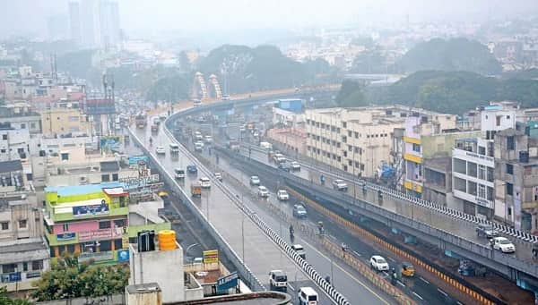
Retteri Flyover is one of North Chennai’s most structurally significant and most heavily trafficked road infrastructure landmarks — a dual flyover system at Retteri Junction in the Kolathur area of Chennai, Tamil Nadu, situated at the busy intersection of Jawaharlal Nehru Salai and the Perambur-Red Hills Road. This is not a single flyover but two separate elevated structures at the same junction — the first flyover, measuring 740 metres in length, was built at a project cost of ₹55.25 crore, while the second flyover addresses the other arm of the cross junction. Located at an altitude of approximately 36 metres above mean sea level at coordinates 13.130240°N, 80.213790°E, the Retteri Flyover complex stands as the primary traffic management infrastructure for one of Chennai’s most congested northern arterial intersections.
The junction carries its unique local name from Rettai Eri — Tamil for “twin lake” — a traditional water body in the Kolathur area that is visible from the 100 feet road running alongside. The Retteri junction is not merely a traffic intersection but a critical node in North Chennai’s road network: vehicles from Anna Nagar via Padi Junction, from Red Hills via Puzhal, from Madhavaram direction, and from Perambur all converge at this single point. The Wikipedia article on Retteri Junction specifically notes that this junction is also used by heavy vehicles such as containers heading to the Ennore port — confirming the flyover’s strategic freight corridor importance alongside its daily commuter traffic function. Yappe.in rates the Retteri Flyover at 4.50 out of 5 stars from 31 reviews, with reviewer Venky Rayarap noting “It’s located at Madhavaram bypass.”
Quick Overview — Retteri Flyover Chennai
| Parameter | Details |
| Name | Retteri Flyover (dual flyover system at Retteri Junction) |
| Location | Kolathur, Chennai, Tamil Nadu — 600099 |
| Full Address | 46J7+5G6, Retteri Flyover, Kolathur, Chennai, Tamil Nadu 600099 |
| Intersection | Jawaharlal Nehru Salai × Perambur-Red Hills Road |
| Flyover Length | 740 metres (first flyover); project cost ₹55.25 crore |
| Altitude | 36 metres above mean sea level |
| Coordinates | 13.130240°N, 80.213790°E |
| Nearest Railway Station | Kolatur Railway Station — 0.68 km |
| Nearest Metro Station | Anna Nagar Tower Metro (Green Line) — 3.16 km |
| Nearest Bus Stops | Retteri Signal — 1 min walk; Retteri — 2 min walk |
| Bus Routes | 113, 121CT, 121M, 142, 170C, 242, 42B, 42D, 42M, 114, 121, 514, 114 CUT, 114A, 104, 570, 42C, 29CEX |
| Pedestrian Feature | Subway constructed at junction under both flyovers |
| Future Metro | Chennai Metro Phase 2 (5th corridor) under construction through junction |
| Best For | Kolathur-Madhavaram corridor, Ennore port freight, North Chennai commuters |
Location and Address
Retteri Flyover is located at 46J7+5G6, Retteri Flyover, Kolathur, Chennai, Tamil Nadu — 600099. This Plus Code address anchors the flyover precisely at the Retteri junction in the Kolathur area — Kolathur being one of North Chennai’s most densely populated residential areas, home to a large and economically diverse urban population that relies on the road junction for daily commute and commercial transport. The Jawaharlal Nehru Salai (a major arterial road in North Chennai) crosses the Perambur-Red Hills Road at this junction, creating the multi-directional traffic convergence that necessitated the dual flyover construction.
The junction’s Wikipedia entry provides comprehensive geographic context: “Retteri junction is an important road intersection at Kolathur of Chennai district, Tamil Nadu. It is located at the intersection of Jawaharlal Nehru Salai and Perambur-Red Hills road at Kolathur. It is also used by heavy vehicles such as containers that lead to Ennore port.” The Ennore port connection is significant — heavy commercial vehicles carrying containers for one of South India’s most important ports use this junction, adding industrial freight traffic to the already dense passenger traffic.
A pedestrian subway constructed on Jawaharlal Nehru Salai at the junction, under both flyovers, provides safe pedestrian crossing — a critical safety feature given the enormous vehicle volumes passing through this intersection from multiple directions simultaneously.
Directions — Getting To and Through Retteri Flyover
From Anna Nagar via Padi Junction (Westward Approach): Vehicles approaching from Anna Nagar direction travel via Padi Junction and reach Retteri Junction on Jawaharlal Nehru Salai from the western side. The flyover’s western arm elevates this through-traffic over the Perambur-Red Hills Road crossing. Motorists continuing toward Madhavaram, Red Hills, or the Ennore port direction use the flyover to bypass surface-level signal stops.
From Red Hills via Puzhal (Northward Approach): Heavy commercial vehicles carrying Ennore port containers, as well as private vehicles from Red Hills, Puzhal, and northern Chennai suburban areas, approach Retteri Junction from the north via the Perambur-Red Hills Road. The flyover structure provides the elevated crossing for this traffic axis over Jawaharlal Nehru Salai.
From Madhavaram Direction: Vehicles from Madhavaram — one of North Chennai’s most rapidly developing residential and commercial zones — approach Retteri Junction through the Madhavaram bypass corridor. The junction’s flyover system allows Madhavaram-direction traffic to navigate the busy intersection efficiently without surface-level bottlenecks.
From Perambur Direction: Traffic from Perambur — a significant Chennai suburban area with its own railway station and commercial character — reaches Retteri Junction from the south, using the Perambur-Red Hills Road direction of the junction.
Routes and Transit Connectivity
By Chennai Suburban Railway — Kolatur Station at 0.68 km: Kolatur Railway Station is just 0.68 km from Retteri Flyover — confirmed by Yappe.in. This sub-700-metre proximity makes suburban rail one of the most practical transit options. The Chennai suburban rail network connects Kolatur to Chennai Beach, Egmore, Central, and the longer Beach-Tambaram corridor. First EMU service passes through the area at 3:54 AM, with last service at 12:37 AM — covering the full daily operational period.
By Chennai Metro — Green Line (Phase 2 Under Construction): Anna Nagar Tower Metro Station on the Green Line is 3.16 km away — the nearest currently operational metro station. More significantly, Chennai Metro Rail Limited’s Phase 2 (5th corridor) is under active construction through the Retteri junction area. Wikipedia confirms: “This route starts from Madhavaram and ends at Sholinganallur via Retteri junction. From Madhavaram to Retteri junction, the metro line is being constructed as an elevated corridor. For this, pillar construction works are finished and bridge works are on progress.” Once Phase 2 operations begin, Retteri will become a direct metro station — dramatically improving public transit accessibility.
By MTC Bus — Over 20 Routes: Bus routes 113, 121CT, 121M, 142, 170C, 242, 42B, 42D, 42M, 114, 121, 514, 114 CUT, 114A, 104, 570, 42C, and 29CEX serve the Retteri area — with Retteri Signal stop at 1 minute and Retteri stop at 2 minutes walking distance. This comprehensive bus network connects Retteri Flyover to Koyambedu, Perambur, Villivakkam, Kolathur, and multiple other Chennai zones.
Nearby Places — Kolathur and North Chennai
Kolathur Residential Zone: Kolathur is one of North Chennai’s most established residential areas — a densely populated neighbourhood with local markets, religious institutions, schools, and the neighbourhood infrastructure that serves a large community. The area’s vibrant street food culture, local temples, and the traditional neighbourhood character create an authentic Chennai urban experience.
Rettai Eri (Twin Lake): The Rettai Eri lake visible from the 100 feet road near the junction is one of the traditional water bodies that gives Retteri its name. The lake provides a natural landscape feature within the urban density of Kolathur.
Madhavaram and Industrial Zones: The Madhavaram direction from Retteri leads to one of North Chennai’s most actively developing commercial and industrial zones. Madhavaram’s residential expansion, its proximity to the Ennore Port’s economic activity, and the container movement industry collectively define the commercial character of this corridor.
Frequently Asked Questions (FAQs)
Q: What is the full address of Retteri Flyover?
A: 46J7+5G6, Retteri Flyover, Kolathur, Chennai, Tamil Nadu — 600099.
Q: How many flyovers are at Retteri Junction?
A: Two flyovers — one measuring 740 metres at a cost of ₹55.25 crore. Both address different arms of the Jawaharlal Nehru Salai × Perambur-Red Hills Road intersection.
Q: How far is Kolatur Railway Station from Retteri Flyover?
A: Just 0.68 km — approximately 8–9 minutes walking distance.
Q: When will Chennai Metro reach Retteri Flyover?
A: Chennai Metro Phase 2 (5th corridor) from Madhavaram to Sholinganallur via Retteri is under active construction with pillar and bridge works in progress, targeting completion around 2025–2026.
Q: Why do container trucks use Retteri Junction?
A: Retteri Junction is on the route connecting Chennai city to Ennore Port — one of South India’s most important commercial ports — making it a critical freight corridor for heavy container vehicles.