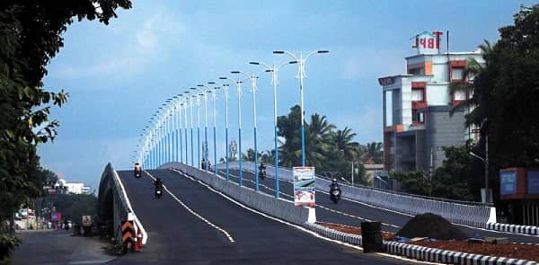
Palarivattom Flyover is one of Kerala’s most discussed and most infrastructure-significant elevated road structures — a flyover at Palarivattom Junction on the Kochi Bypass (NH 66 / Kochi Bypass Road) in Palarivattom, Kochi, Kerala — 682025, serving the critical four-directional intersection that Wikipedia confirms is Palarivattom’s most defining feature: “Palarivattom is a ward of Kochi, Kerala. It is known for a four-directional intersection at its highway signal point on the Kochi Bypass. The district is a commercial area, which gained importance as a connecting point between the city’s different taluks when the district’s administration was moved to the nearby suburb of Kakkanad.” The flyover gained national attention beyond its engineering importance for the controversial circumstances surrounding its structural integrity — the structure was found to have defects, was demolished, and its reconstruction has become one of Kerala’s most prominent infrastructure accountability cases.
The current infrastructure development context is defined by a remarkable 2025 NHAI project: Swarajya Mag reports “Kochi’s proposed flyover at Palarivattom Bypass Junction, part of the Edappally–Aroor elevated highway, has been realigned to pass above the Kochi Metro’s Phase-2 viaduct. According to the revised DPR submitted by Bhopal-based Highway Engineering Consultants Ltd, the new structure will rise 32 metres above the existing flyover and the under-construction Pink Line metro viaduct.” This extraordinary 32-metre height — a flyover above a metro viaduct above an existing flyover — reflects the extraordinary geometric complexity of Palarivattom Junction and the layered infrastructure investment that Kochi’s central highway corridor is receiving.
Quick Overview — Palarivattom Flyover Kochi
| Parameter | Details |
| Name | Palarivattom Flyover |
| Location | Palarivattom Junction, Kochi Bypass (NH 66), Palarivattom, Kochi — 682025, Kerala |
| Highway | NH 66 (Kochi Bypass) |
| Junction Character | Four-directional intersection — major Kochi Bypass signal point |
| Nearest Metro Station | Palarivattom Metro Station (Orange Line) |
| Area | Palarivattom, Ernakulam district |
| Administrative Significance | Connection between Kochi’s different taluks; gateway to Kakkanad |
| Future Infrastructure | NHAI Edappally–Aroor elevated highway to pass 32m above; Pink Line metro viaduct |
| Nearby Landmarks | JN Stadium — 1.8 km; Palarivattom Bridge — 1.7 km |
| District HQ Access | Kakkanad (district administration) nearby |
| Languages | Malayalam, English |
| Best For | Kochi Bypass users, Kakkanad corridor, inter-taluk traffic |
Location and Address
Palarivattom Flyover is located at Palarivattom Junction on the Kochi Bypass Road, Palarivattom, Kochi — 682025, Kerala. The junction is the four-directional intersection that defines Palarivattom’s geographic character — described universally across multiple sources as the area’s most important and most recognisable feature. The Kochi Bypass (part of NH 66, the Mumbai-Kanyakumari coastal highway) creates the primary east-west traffic axis, while local road connections to Kakkanad, Kaloor, and Ernakulam city centre create the north-south cross-traffic that has historically generated the junction’s notorious congestion.
Palarivattom’s name comes from Malayalam — “Palari” meaning a pool or pond and “Vattom” meaning round or circular, referring to a traditional round pool that historically occupied this location. This etymological context reflects the area’s transformation from a rural water management feature into one of Kochi’s most commercially and administratively important intersections — a journey from pastoral history to metropolitan significance that Kerala’s coastal commercial cities have followed across several centuries.
The 2025 NHAI flyover realignment is particularly significant — the revised DPR for a new elevated highway structure rising 32 metres above the existing flyover level (above the Kochi Metro’s Pink Line Phase-2 viaduct under construction) reflects the national government’s recognition that Palarivattom Junction requires multi-level infrastructure investment to manage the traffic volumes generated by the Edappally-Aroor corridor.
Directions — Getting To and Through Palarivattom Flyover
From Edappally Direction (LuLu Mall Area): Vehicles from Edappally — where LuLu Mall, one of Asia’s largest shopping complexes, is located approximately 3.3 km from Palarivattom — approach the flyover from the north on NH 66. This direction carries the enormous LuLu Mall visitor traffic, the Edappally commercial zone commuters, and the Aluva-direction highway traffic through the Palarivattom Junction.
From Kochi City Direction (Ernakulam): Vehicles from Ernakulam’s commercial district — the Marine Drive, MG Road, and the Ernakulam junction area — approach Palarivattom from the west. This direction serves the enormous daily commuter flow between Kochi’s central business district and the Kakkanad, Infopark, and Kalamassery IT zones that have grown east of Palarivattom Junction.
Toward Kakkanad and Infopark: The Kakkanad direction from Palarivattom leads to Kakkanad — the district headquarters of Ernakulam — and Infopark Kochi, one of Kerala’s largest IT Special Economic Zones housing major global technology companies. This direction carries the largest single directional traffic flow from the junction during IT work hours.
Toward Kochi Airport (Via Aroor-Edappally): The NH 66 direction through Palarivattom is part of the primary surface road from Kochi city toward Kochi International Airport at Nedumbassery — approximately 30 km via the Edappally-Aluva corridor. The NHAI Edappally-Aroor elevated highway project (of which the new Palarivattom flyover is a component) will provide uninterrupted elevated travel on this critical airport access corridor.
Routes and Transit Connectivity
By Kochi Metro — Orange Line: Palarivattom Metro Station on the Kochi Metro Orange Line is the primary metro access point — the station’s proximity to the junction provides metro connectivity from Aluva (through Edappally and toward the LuLu Mall terminus) and toward Petta, MG Road, and the Ernakulam South direction. The Orange Line’s connection to LuLu Mall Edappally through the direct covered walkway integration makes the metro system the most practical transit option for commercial visitors.
The upcoming Pink Line Phase-2 metro viaduct — under construction through the Palarivattom Junction — will add a second metro line and a metro station to the Palarivattom area, creating an extraordinary two-line metro access node at one of Kerala’s busiest junctions.
By KSRTC and Private Bus: Multiple KSRTC and private bus routes serve the Palarivattom Junction from across Ernakulam district, Thrissur, Alappuzha, and the broader Kerala road network. The junction’s status as the Kochi Bypass’s central intersection ensures bus route convergence from virtually all directions.
By Road NH 66 and the local road network provide vehicle access from all Kochi zone directions. Ola and Uber maintain strong availability in the Palarivattom commercial area.
Nearby Places — Kochi’s Commercial and Sporting Character
Jawaharlal Nehru International Stadium (Kaloor): JN International Stadium — approximately 1.8 km from Palarivattom — is Kochi’s primary multi-purpose sports facility, hosting international cricket matches, Indian Super League football (Blasters FC), and national-level tournaments. The stadium’s events generate significant traffic through the Palarivattom corridor.
LuLu Mall Edappally: The iconic LuLu Mall — 3.3 km from Palarivattom — is one of India’s largest shopping complexes with over 250 stores, a hypermarket, cinema, ice skating rink, and food courts. LuLu Mall’s massive daily visitor footfall makes the NH 66 through Palarivattom one of Kerala’s highest-traffic commercial corridors.
Infopark Kochi: Infopark Kochi — accessible via the Kakkanad direction from Palarivattom — is Kerala’s most important IT park, housing global companies including HCL, TCS, UST Global, and dozens of multinational organisations. The IT workforce’s daily commute through Palarivattom Junction is one of the primary traffic drivers that makes the flyover infrastructure investment essential.
Palarivattom Mahadeva Temple: The ancient Palarivattom Mahadeva Temple — 2.6 km from the junction — is a revered Shiva temple of architectural and spiritual significance, drawing pilgrims from across Kochi throughout the year.
Frequently Asked Questions (FAQs)
Q: Where is Palarivattom Flyover located?
A: At Palarivattom Junction on the Kochi Bypass (NH 66), Palarivattom, Kochi — 682025, Kerala.
Q: What makes Palarivattom Junction significant?
A: It is a four-directional intersection on the Kochi Bypass that connects the city’s different taluks — and serves as the gateway between Ernakulam’s CBD and the Kakkanad/Infopark IT corridor.
Q: What new flyover infrastructure is planned at Palarivattom?
A: NHAI is building a new flyover 32 metres above the existing level, part of the Edappally-Aroor elevated highway — realigned to pass above the Kochi Metro Pink Line Phase-2 viaduct under construction.
Q: Which metro station serves Palarivattom Flyover?
A: Palarivattom Metro Station on the Kochi Metro Orange Line, with the Pink Line Phase-2 adding a second station.
Q: How far is LuLu Mall from Palarivattom?
A: Approximately 3.3 km via NH 66 toward Edappally.