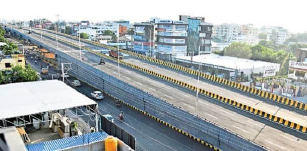
Nagole Flyover is one of Hyderabad’s most recently completed and most eagerly awaited road infrastructure projects in the eastern corridor — a 990-metre-long, 24-metre-wide six-lane bi-directional flyover on the Uppal-LB Nagar stretch, forming part of the GHMC’s Strategic Road Development Programme (SRDP) that has systematically elevated key intersections across the city. Telangana Today’s report provides the defining description: “The 990-m-long and 24-m-wide six-lane bi-directional Nagole flyover promises to ease traffic congestion on the Uppal-LB Nagar stretch and in the opposite direction as well — two of the busiest routes in eastern Hyderabad.” Inaugurated in October 2022, the flyover serves an eastern Hyderabad corridor that has been undergoing rapid development due to the Telangana government’s Growth in Dispersion (GRID) policy, which encourages IT sector companies to establish operations in areas beyond the established HITEC City-Madhapur zone.
The Hans India confirms the flyover’s functional benefits comprehensively: “This flyover will make it easy for commuters to travel from LB Nagar to Uppal towards Yadadri-Bhuvanagiri, Warangal, Secunderabad and ECIL. The flyover will provide signal-free traffic movement on both ways on the stretch.” The mention of Yadadri-Bhuvanagiri — Telangana’s most important new Hindu pilgrimage centre and a destination for hundreds of thousands of devotees monthly — adds a pilgrimage corridor dimension that makes the Nagole Flyover relevant for far more than daily IT commutes. LB Nagar has simultaneously become a “bustling community over the years, with numerous housing units, office spaces, and commercial businesses rapidly growing in the area, resulting in increased vehicular traffic” — reflecting the residential boom that eastern Hyderabad has experienced alongside the IT sector expansion.
| Parameter | Details |
| Name | Nagole Flyover |
| Location | Nagole, Uppal-LB Nagar stretch, Hyderabad, Telangana |
| Length | 990 metres |
| Width | 24 metres |
| Lanes | 6-lane, bi-directional |
| Inaugurated | October 2022 |
| Project | SRDP (Strategic Road Development Programme) |
| Key Corridor | Uppal ↔ LB Nagar |
| Metro Station | Nagole Metro Station (Blue Line, C3) — eastern terminus |
| Inner Ring Road | Adjacent to Nagole |
| Bus Routes | 279, 300, 300A, TGSRTC services, 90L, 113M/W |
| Key Beneficiaries | Samathapuri Colony, Bandlaguda, RK Puram, LB Nagar residents |
| IT Firms Served | Genpact, 24/7 Customer Pvt Ltd, Uppal IT companies |
| Best For | Eastern Hyderabad IT corridor, LB Nagar-Warangal-ECIL highway users |
Location and Address
Nagole Flyover is located on the Uppal-LB Nagar Road in Nagole, eastern Hyderabad, Telangana. The flyover is positioned near Nagole Metro Station on the Blue Line’s Inner Ring Road — Nagole being the eastern terminus of the Blue Line (C3-BLUE), making it the point where the metro network’s easternmost reach meets the newly elevated road infrastructure.
The NoBroker assessment confirms: “Nagole Metro Station is centrally located in Nagole. The distance from the station’s exit gates to the main Nagole X Roads, the Inner Ring Road, and the Uppal RTO Office is minimal.” This proximity creates a uniquely integrated transit and road infrastructure environment — pedestrians and commuters can access both the metro and the flyover within a short walk of each other, creating genuine multi-modal connectivity in this eastern corridor.
The Uppal-LB Nagar stretch is one of eastern Hyderabad’s most strategically important road corridors. Uppal has established itself as Hyderabad’s newest IT concentration zone — with Genpact, 24/7 Customer Pvt Ltd, and multiple small and medium IT firms confirmed by TSITC officials as already operating in the area. LB Nagar has grown from a modest suburban node into a major residential and commercial hub within a decade, driven by affordable housing development and the proximity of employment zones.
Directions — Getting To and Through Nagole Flyover
From LB Nagar toward Uppal and Eastern Hyderabad: Vehicles from LB Nagar — the rapidly growing residential and commercial hub in the southwestern part of Nagole’s broader catchment — approach the Nagole Flyover from the southwestern end. The flyover provides signal-free travel over the previously congested Nagole crossroads, continuing toward Uppal IT parks, Secunderabad, ECIL, and the Yadadri-Bhuvanagiri pilgrimage highway. The Hans India’s resident Sai Shekhar from Samathapuri Colony confirms: “Traffic on the Nagole main road will be reduced and will make it easy for the localities to commute.”
From Uppal toward LB Nagar and Warangal: Vehicles from the Uppal direction — approaching from Secunderabad, Malkajgiri, ECIL, and the Warangal highway — approach the flyover from the northeastern end. The bi-directional design carries this substantial inter-city traffic over the Nagole surface junction, significantly reducing the travel time for commuters who previously faced signal stops at the busiest sections of this corridor.
Alternate Access for Service Roads: The service road infrastructure adjacent to the flyover provides access to Samathapuri Colony, Bandlaguda, RK Puram, and the residential zones adjacent to the main road. Residents of these localities use the service roads to access the flyover or to navigate the now-less-congested surface roads below.
Routes and Transit Connectivity
By Hyderabad Metro — Blue Line Terminus: Nagole Metro Station is the eastern terminus of the Hyderabad Metro Blue Line (C3-BLUE) — the most important metro station in this corridor. The station opened in 2017 and provides connectivity from Nagole through Uppal, LB Nagar Metro, Mettuguda, Tarnaka, Musheerabad, Ameerpet, Begumpet, Hitech City, and toward the western terminus at Raidurg in the Financial District. First Blue Line service at 6:00 AM, last service at 11:48 PM. The station is described as having “high peak-hour frequency of every 5–8 minutes” making it the most reliable transit option for the enormous daily commuter population.
By TSRTC Bus: Bus routes 279, 300, 300A, TGSRTC express services, 90L, and 113M/W serve the Nagole Metro Station area with stops within walking distance of the flyover. Additional TGSRTC long-distance services connect Nagole to Warangal, Nalgonda, and the broader Telangana state highway network. Uppal X Road bus stop is listed as the closest destination to Nagole Metro Station, with the Stadium stop also within the service area.
By Road — Uppal-LB Nagar Highway: The Uppal-LB Nagar Road (part of the Inner Ring Road corridor) provides the primary vehicle approach from both directions. Ola and Uber maintain strong availability in the Nagole area given the enormous IT professional population of Uppal and LB Nagar.
Nearby Places — Eastern Hyderabad’s Growth Corridor
Uppal IT Parks and Technology Zone: Uppal’s rapidly developing IT corridor — with Genpact, 24/7 Customer Pvt Ltd, and dozens of smaller IT firms — is directly accessible from the Nagole Flyover’s northeastern exit. The GRID (Growth in Dispersion) policy has specifically targeted Uppal as one of the eastern technology zones that will absorb IT sector growth previously concentrated in the western HITEC City corridor.
LB Nagar — Eastern Hyderabad’s Residential Hub: LB Nagar’s transformation into a major residential and commercial hub with “numerous housing units, office spaces, and commercial businesses rapidly growing” makes it the primary residential catchment for the flyover. The LB Nagar bus terminus — one of Hyderabad’s most important intercity bus departure points — is accessible from the flyover zone.
Yadadri Bhuvanagiri — New Pilgrimage Centre: The Yadadri Bhuvanagiri temple — Telangana’s most important newly developed Hindu pilgrimage centre, built on a hilltop approximately 60 km from Nagole — is accessible via the highway corridor that the Nagole Flyover opens. The state government’s investment in this pilgrimage centre and the highway leading to it makes the flyover a critical pilgrimage access route.
Frequently Asked Questions (FAQs)
Q: How long is the Nagole Flyover?
A: 990 metres — 24 metres wide with 6 lanes, bi-directional, inaugurated October 2022 as part of GHMC’s SRDP.
Q: Which metro station is nearest to Nagole Flyover?
A: Nagole Metro Station on the Blue Line — the eastern terminus of the Blue Line — is directly adjacent, approximately 1 minute walking from the flyover zone.
Q: What traffic junctions does Nagole Flyover help bypass?
A: The flyover provides signal-free movement on the Uppal-LB Nagar stretch, eliminating surface-level stops that previously slowed this major eastern corridor.
Q: Which destinations does Nagole Flyover serve?
A: LB Nagar, Uppal, Secunderabad, ECIL, Warangal, and Yadadri-Bhuvanagiri — covering both daily commuter and intercity pilgrimage traffic.
Q: Who benefits most from Nagole Flyover?
A: Residents of Samathapuri Colony, Bandlaguda, RK Puram, and LB Nagar, along with IT professionals commuting to Uppal’s technology parks and pilgrims heading to Yadadri.